KT3D_H2O
KT3D_H2O Version 3.0 - A Program for Kriging Water Level Data using Hydrologic Drift Terms.
KT3D_H2O Version 3.0 is a graphical user interface (GUI) that combines various programs to generate gridded maps of water level elevations, together with approximate particle tracks and capture zones.
These tools combine the geostatistical and hydrological sciences to allow the user to support mapping-based hydrogeologic analyses without reverting to numerical models of groundwater flow.
KT3D_H2O is developed as a plug-in application under the open-source GIS foundation MapWindow and it is assumed that the user has already installed the latest version of MapWindow program, which can be downloaded at (www.MapWindow.org)
Please Note: KT3D_H2O has been deprecated and is no longer actively maintained by SSP&A. Users running KT3D_H2O on newer versions of Windows may experience user interface related problems. Current and future development of this software functionality has migrated to Groundwater Desktop.
Background
Though kriging is widely used as the preferred method for constructing gridded water level datasets suitable for contouring, residuals arising from using the most common (linear) drift to krige water levels in the vicinity of extraction wells often indicate large local departures from the linear drift, which correlate with areas of drawdown. These are evident in plan view (e.g. Figure 2) and cross-section (e.g. Figure 3). Using linear-log kriging, ground water levels measured in the vicinity of pumping wells are kriged using a regional-linear and point-logarithmic drift, the latter derived from the Thiem equation.
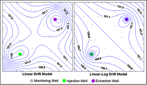
Figure 2. Gridded Water Level data - Plan View.
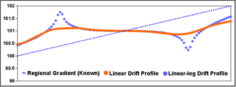
Figure 3. Gridded Water Level data - Section View.
Hence, the combined regional-linear and point-logarithmic drift accounts for drawdowns (or mounding, in the case of injection wells) using a logarithmic approximation for the curvature of the potentiometric surface. Since the drift model approximates the principal physical processes that govern ground water flow and govern the auto-correlation of ground water elevation data, this approach produces maps of contoured water levels that more realistically represent physical conditions and that allow for improved interpretation of measured water-level data. Additional benefits include an improved estimate of the background hydraulic gradient and generation of an grid suitable for two-dimensional particle tracking.
Main Features
- Single and multi event gridding;
- Multiple drifts can be applied simultaneously;
- The effects of heterogeneity can be approximated by allowing different drifts to be applied to different groups of features (e.g., wells);
- Forward and backward particle tracking;
- Single Event, Multi Event and Transient Particle Tracking;
- Easy particle starting locations setup;
- Hydraulic capture zone analysis (including capture frequency maps).
KT3D_H2O allows the user to generate gridded maps of water level elevations that include the following elements that have important influence on the shape of the mapped surface and are usually ignored by other gridding software applications:
- Point Sink or Source of Known Strength: accounts for mounding (or drawdown) in response to injection (or extraction) at a known rate at one or more wells.
- Horizontal Line Sink or Source of Known Strength: accounts for mounding (or drawdown) in response to finite-length horizontal linear features of known extraction (injection) rate, such as interception trenches or infiltration galleries; and
- Circular Leaking Pond of Known Strength: accounts for the potentiometric response of a water table (unconfined) aquifer to infiltration through the base of a perched, circular pond.
The available drift terms can be applied simultaneously, i.e. a single gridded surface may contain
one or more point sink(s)/source(s), one or more horizontal line sink(s)/source(s) and one or more circular leaking pond(s). In addition, in order to account for heterogeneity, different groupings of the drift features are possible so that the regression coefficients (‘scaling’) calculated through the universal kriging is performed separately for each drift group to obtain a best fit. For example: wells located in a high transmissivity area can be assigned to Point Sink Drift Term 1 and wells located in a low transmissivity area can be assigned to Point Sink Drift Term 2.
These gridded surfaces can be used to complete the following types of hydrogeologic analyses maps for single or multiple events:
- Maps of water level elevations;
- Maps showing approximate particle traces (particle tracking); and
- Maps of approximate hydraulic capture for use in capture zone analysis; and
- Maps of capture frequency.
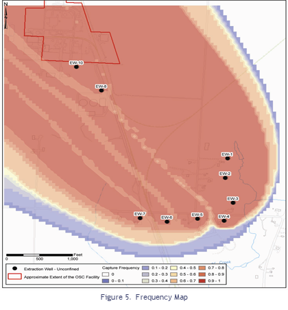
The combined results of the approximate capture zone analyses can be used to evaluate the robustness of hydraulic capture, and identify areas where capture may be compromised. Capture frequency maps are generated by:
- Processing multiple water level events, each with unique pumping rate data; producing groundwater elevation contours for each event;
- Undertaking particle tracking on each surface and recording the fate of each particle; and,
- Summarizing the results in terms of the fraction of the events for which each particle was removed at an extraction well.
For example, a frequency of 0.5 illustrates that on the basis of the measured water levels, the assumed measurement errors, and the gridding approach employed, a particle would be captured by the remedy about 50 percent of the time. Hence, these maps illustrate the relative frequency with which particles of groundwater are captured under the varying conditions represented by different water level events. It should be noted that the capture frequency maps generated this way are qualitative and are not founded on prior information of the correctness or suitability of the mapping approach.
A full description of the linear-log drift is given in the paper:
Tonkin, Matthew J., and Larson, Steven P., 2002. "Kriging Water Levels with a Regional-linear and Point-logarithmic Drift". Ground Water, March/April 2002.
A new Ground Water Methods Note describes (a) expansions to the techinque described by Tonkin and Larson (2002); (b) the concept of the capture frequency map (CFM), a technique that combines information from multiple capture zone maps into a single depiction of capture; (c) the development of a graphical user interface to facilitate the use of the methods described; and (d) the integration of these programs within the MapWindow geographic information system environment. An example application is presented that illustrates ground water level contours, capture zones, and a CFM prepared using the methods and software described.
Karanovic, Marinko, Tonkin, Matthew, and Wilson, David, 2009. "KT3D_H2O: A Program for Kriging Water Level Data Using Hydrologic Drift Terms". Ground Water, July/August 2009.
Brochu and Marcotte (2003) describe a similar kriging approach and present theory on the inclusion of boundary conditions, the use of image wells, and the estimation of aquifer parameters.
Brochu, Y. and Marcotte, D., 2003. A Simple Approach to Account for Radial Flow and Boundary Conditions When Kriging Hydraulic Head Fields for Confined Aquifers. Mathematical Geology, Vol. 35, No. 2, February 2003.
One of the authors of the article (Denis Marcotte) has published on related geostatistical topics - a list of his publications can be found at his home page:
http://geo.polymtl.ca/~marcotte/
KT3D_H2O is a freeware application and following is available for download:
- KT3D_H20_Setup, a self-executable installation file that will install all necessary Dynamic Link Library files (dll’s), user’s manuals into appropriate MapWindow folders.
- Documentation in Adobe PDF format including instructions on how to obtain Map Window, a free open-source GIS.
These programs are provided FREE of charge. The authors request only that application of the software and production of results using the code is accompanied by a suitable acknowledgment. The software is provided "AS IS", without warranty of any kind, including, without limitation, the warranties of merchantability, fitness for a particular purpose and non-infringement. The entire risk and responsibility as to the quality and performance of the Software is borne by the user. The author(s) disclaim all other warranties.
The following text from the GSLIB KT3D program details the copyright and distribution rights pertaining to the GSLIB programs.
“Copyright (C) 1996, The Board of Trustees of the Leland Stanford Junior University. All rights reserved. The programs in GSLIB are distributed in the hope that they will be useful, but WITHOUT ANY WARRANTY. No author or distributor accepts responsibility to anyone for the consequences of using them or for whether they serve any particular purpose or work at all, unless he says so in writing. Everyone is granted permission to copy, modify and redistribute the programs in GSLIB, but only under the condition that this notice and the above Copyright notice remain intact.”